


Mgrs & Utm Map

คำอธิบายของMgrs & Utm Map
แอปพลิเคชั่นนี้เป็น GPS และประสานงานผู้ช่วยระบบโดยเฉพาะอย่างยิ่งสำหรับบุคลากรทางทหาร
นอกจากนี้ยังเป็นผู้ช่วยที่สมบูรณ์แบบสำหรับการปีนเขาการเดินป่าและปีนเขาการวิ่งข้ามลูกเสือการล่าสัตว์การตกปลาการ geocaching การเดินเรือนอกถนนและกิจกรรมกลางแจ้งและกีฬาอื่น ๆ
ด้วยระบบนำทางผ่านดาวเทียมเช่น GPS, GALILEO และ GLONASS (GNSS) ที่อุปกรณ์ของคุณรองรับและเซ็นเซอร์คุณสามารถเห็นตำแหน่งที่แม่นยำที่สุดของคุณในแผนที่เลเยอร์ต่างๆ
คุณสมบัติ:
* ง่ายและเร็วขึ้น
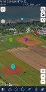
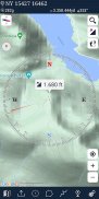
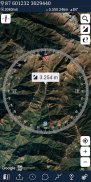
* เข็มทิศ
=> เข็มทิศบนแผนที่ (บนแผนที่ที่แสดงทิศทางของคุณ)
=> เข็มทิศเท่านั้น (แสดงทิศทางทางกายภาพ)
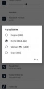
=> หน่วยเชิงมุมสำหรับเข็มทิศ (องศา, NATO mil, Soviet Mil, Grad)
* โหมดติดตาม
=> ศูนย์กลางของแผนที่จะติดตามตำแหน่งของคุณขณะเดินทาง
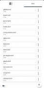
* คุณสามารถเพิ่มและลบเครื่องหมาย
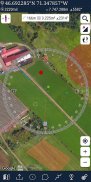
* วัดระยะทาง (คุณสามารถเพิ่มเส้นทางที่กำหนดเองและคำนวณระยะทางทั้งหมด)
* การวัดพื้นที่ (คุณสามารถเลือกพื้นที่บนแผนที่และคำนวณพื้นที่เป็นตารางเมตร)
* คุณสามารถดูความสูงของที่ตั้งของคุณ
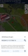
* คุณสามารถค้นหาตำแหน่งตามรูปแบบองศา / นาที / วินาที, MGRS, UTM หรือละติจูด / ลองจิจูด
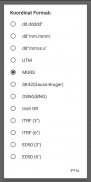
* ตัวเลือกรูปแบบที่ตั้ง (พิกัด)
=> MGRS / US กริดแห่งชาติ (USNG) (WGS84 / NAD83)
=> D ° M'S "(WGS84)
=> ละติจูด / ลองจิจูด (WGS84)
=> UTM (WGS84 / NAD83)
=> SK42 (Gauss Kruger)
* ตัวเลือกประเภทแผนที่ (ถนน, ภูมิประเทศ, ดาวเทียม, โหมดกลางคืน, ไฮบริด)
* คุณสามารถแบ่งปันพิกัดตำแหน่ง
* ตัวเลือกหน่วยระยะทาง (เมตรและฟุต)
* โปรแกรมดู KML (ส่งออกและนำเข้าเลเยอร์ KML)
* เครื่องบันทึกติดตาม GPS
Mgrs & Utm Map--เวอร์ชั่น7.3.5
(01-01-2025)
Mgrs & Utm Map - ข้อมูล APK
เวอร์ชั่น APK: 7.3.5แพ็คเกจ: com.zahidcataltas.mgrsharitaเวอร์ชั่นล่าสุดของMgrs & Utm Map
เวอร์ชั่นอื่น


แอปในประเภทเดียวกัน


